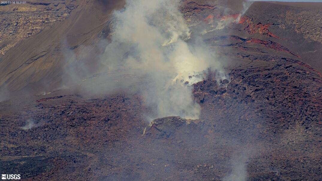
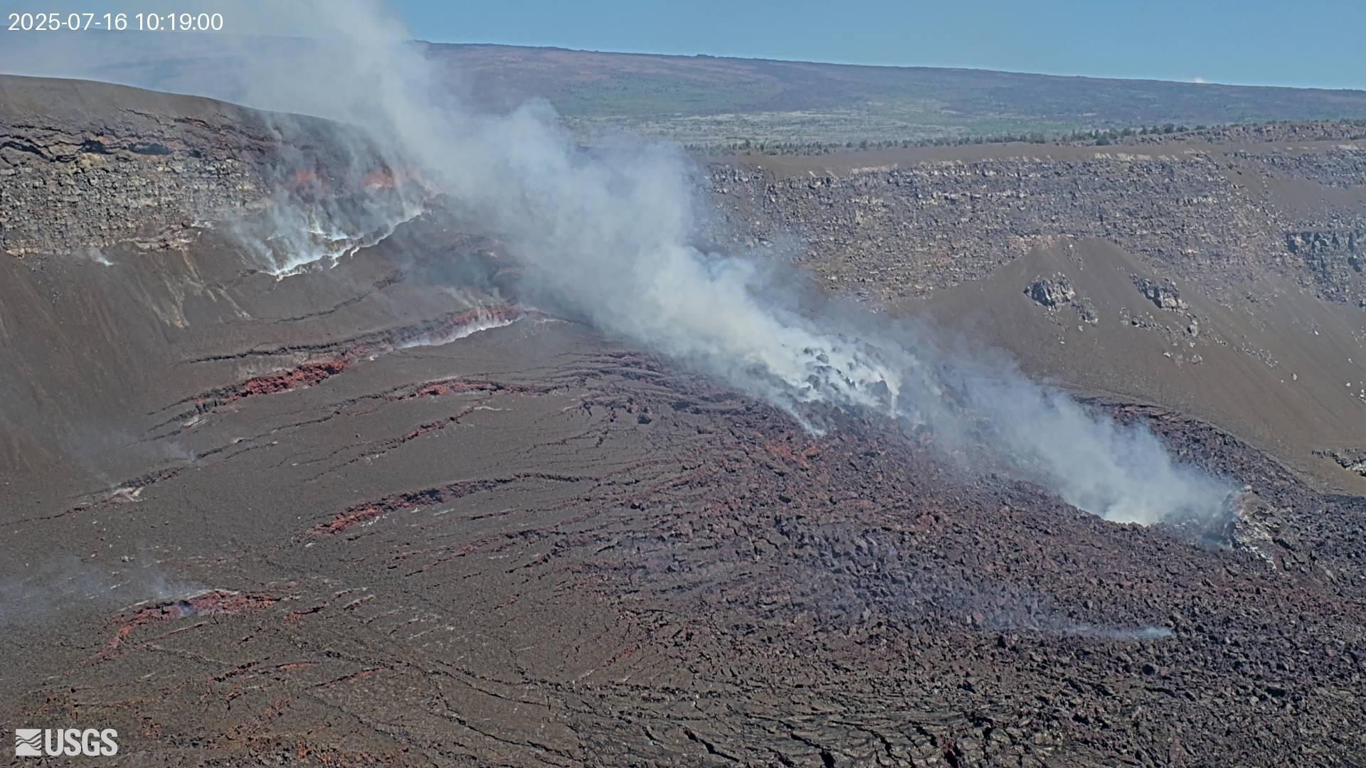
🌋 Active Eruption: Kīlauea has been erupting episodically since December 23, 2024, from two vents in Halema'uma'u crater. Fountaining episodes typically last <12 hours, separated by pauses of 1–3+ weeks.
45
Precursory activity began Apr 21
Three cameras (V1, V2, V3) livestream 24/7 to YouTube. During fountaining episodes, these are the best seats in the house. Click to watch live.
Live snapshots updated every few minutes. Images from USGS/HVO — public domain. Click any image for the 24-hour animated GIF.
Earthquakes within 100 km of Kīlauea summit, past 7 days. Data from USGS Earthquake Hazards Program.
This is your war room. These are the same data feeds HVO scientists use to forecast fountaining episodes. The tilt plot is the single most important indicator — learn to read the sawtooth and you'll know when the next episode is coming.
The UWD tiltmeter near Uēkahuna on the caldera rim is your best friend. It measures ground tilt in microradians (μrad) — one microradian is like tilting a kilometer-long beam by one millimeter. Here's what to watch for:
📈 RAMP UP (Inflation) — Magma filling the shallow reservoir. Ground swells outward. Tilt climbs steadily over days/weeks. This is the pause between episodes. When you see ~20-25+ μrad accumulated, an episode is approaching.
🔥 PRECURSORY OVERFLOWS — Lava spills from the vents as the magma column pushes to the surface. Small dome fountains and spattering. The pot is starting to boil over. Overflows can pause during brief deflation events, then resume when inflation returns.
⬇️ CLIFF (Deflation) — The fountaining episode begins. Rapid tilt drop as the reservoir empties through the vents. This happens fast — ep. 43 recorded 33.9 μrad of deflation in ~9 hours. South vent fountains reached 1,770 ft (record through ep. 43).
🔄 IMMEDIATE REBOUND — Episode ends abruptly. Inflation restarts immediately as new magma refills from below. The cycle begins again.
The sawtooth pattern in the tilt record since December 2024 shows every single episode since December 2024 — each ramp and cliff marking a pause and fountain cycle. The heartbeat of the eruption. As pauses have lengthened (from days to weeks), the ramps grow taller before each cliff. HVO uses inflation rate and accumulated tilt to forecast the next episode window.
These USGS pages contain live-updating plots generated from real-time instrument data. Bookmark these for your trip.
The most important page on the internet for tracking this eruption. Shows the UWD tilt curve (the sawtooth), crater floor elevation from the laser rangefinder, and earthquake depth/frequency plots — all for the past 7 days.
📊 Open Past Week Data on USGS.gov ↗
Wider view showing the full inflate-deflate cycle across recent episodes. Includes sulfur dioxide emission rates and earthquake energy release. Best for seeing where we are in the longer pattern.
📊 Open Past Month Data on USGS.gov ↗
The entire sawtooth — every episode since the eruption began. Every ramp and cliff since December 2024. This is the plot that tells the whole story. Also includes the crater floor laser rangefinder showing the lava level rising with each episode.
📊 Open Eruption Information on USGS.gov ↗
ArcGIS web map showing all HVO monitoring stations — tiltmeters, GPS, seismometers, webcams — with data overlays. Click any station to see its current readings.
🗺️ Open Interactive Map ↗
These short messages from HVO scientists are posted in real time during precursory activity and active episodes. This is the feed to watch when things are heating up.
Real-time vog forecasts, SO₂ concentrations, and air quality data for the Big Island. Essential during and after fountaining episodes.
🌫️ Vog Information Dashboard ↗
Citizen science: report tephra fall in your area and see where ash/Pele's hair is landing during an episode.
🏔️ Report Tephra Fall ↗
Current closures, trail conditions, viewing area status, and eruption viewing info from the National Park Service.
🏞️ Eruption Viewing Guide ↗
🔔 Get notified: Sign up for the
USGS Volcano Notification Service to receive email/text alerts when the alert level changes or a new episode begins. This is the fastest official notification channel.
Kīlauea
"Spewing" or "Much Spreading"
WATCH · Erupting since Dec 23, 2024
Elevation
4,091 ft (1,247 m)
Last Major Eruption
2018 LERZ (Leilani)
Coordinates
19.421°N, 155.287°W
One of the world's most active volcanoes. The current episodic fountaining eruption (43+ episodes) is a style not seen since the 1980s Pu'u 'Ō'ō era.
Mauna Loa
"Long Mountain" — Largest active volcano on Earth
NORMAL · Last eruption: Nov–Dec 2022
Elevation
13,681 ft (4,170 m)
2022 Eruption
NE Rift Zone, 17 days
Coordinates
19.475°N, 155.608°W
Earth's largest active volcano by volume and area. Covers half of the Big Island. The 2022 eruption ended a 38-year dormancy.
Hualālai
Last eruption: 1801
Elevation
8,271 ft (2,521 m)
Mauna Kea
"White Mountain" — Tallest peak in Hawai'i
Elevation
13,796 ft (4,205 m)
Last Eruption
~4,600 years ago
Haleakalā
"House of the Sun" — Maui
Elevation
10,023 ft (3,055 m)
Kama'ehuakanaloa
Formerly Lō'ihi — Submarine seamount
Summit Depth
~3,200 ft below sea
Future
Hawai'i's next island
Since December 23, 2024, Kīlauea has erupted in a distinctive episodic pattern — short-lived lava fountaining from two vents in Halema'uma'u, separated by inflationary pauses. This style was last seen in the 1980s.
Episode 45 — Precursory
April 21, 2026 – present
Precursory lava flows from the north vent began overnight April 20–21. Alert Level raised to WATCH / ORANGE. Summit inflation ongoing since end of episode 44. Episode 45 forecast window: April 19–26.
Episode 44 — Complete
April 9, 2026 · 8.5 hours
Began 11:10 AM HST, ended 7:41 PM. North vent fountains reached 800 ft (240m). Tephra fell into public areas of the park and surrounding communities — softball-sized chunks near Kilauea Military Camp. Park closed during episode. South vent did not fountain. About 7.5M cubic yards of lava covered half the crater floor. Smaller than episodes 41–43.
Episode 43
March 10, 2026 — ~9 hours
Record-breaking episode. South vent fountain reached 1,770 ft (540 m) — tallest of the eruption. North vent peaked above 1,300 ft. UWD tiltmeter recorded 33.9 μrad of deflation. Tephra fall blanketed Volcano Village, Highway 11, and reached Hilo. Park and highway temporarily closed.
Episode 42
February 15, 2026
North vent fountain reached ~300 m (~1,000 ft). Helicopter overflight Feb 26 mapped crater floor changes.
Episode 41
January 2026
Fountains from both vents reached 500–650 ft (150–200 m). Tephra fall reported in park, Volcano Village, and Highway 11.
Episode 40
January 12, 2026
Occurred within forecast window of Jan 8–14.
Episode 39
December 24, 2025
Marked one year of episodic activity. Cooling flows visible on crater floor.
Episodes 1–38
Dec 23, 2024 – Dec 2025
First year of episodic fountaining. Extensive tephra deposits, vent cone growth, lava lake rebuilding.
⚠️ For your trip: The eruption is within a closed area of Hawai'i Volcanoes National Park. Check the
NPS website for current conditions before visiting. Episode 44 could occur during your visit — you might see fountaining!
🌫️
Vog
Volcanic smog from SO₂
🧵
Pele's Hair
Glassy fibers — irritant
🔥
Lava Fountains
Confined to caldera
💨
Volcanic Gas
H₂O, CO₂, SO₂
⚡
Ground Cracking
Caldera rim instability
🏔️
Tephra Fall
Ash & pumice downwind