The Pocket Fire, three weeks into its run through the Red Rock–Secret Mountain Wilderness north of Sedona, has grown to 26,803 acres and reached 51% containment as of Tuesday morning, July 7. The fire has now surpassed the 21,227-acre Slide Fire of 2014 to become the largest Sedona-area burn in over a decade. Command changed hands on Sunday, July 5, when California Interagency Incident Management Team 6 relieved Southwest Complex Team 2 with no break in operations. And in a shift that would have felt improbable on the morning this report was first written — Friday, June 26, when the fire sat at 1,467 acres with zero containment ahead of a three-day Red Flag Warning — Sedona itself is now open for business, with only Oak Creek Canyon and the Seven Canyons/Enchantment areas remaining in SET status.
The Red Flag weekend of June 27–29 came and went without the catastrophe that had been feared. Winds gusted, humidity dropped, and the fire did grow — nearly quadrupling in size over that weekend and the days that followed, from about 1,467 acres to over 17,000 by Wednesday, July 1 — but it grew northeast into remote wilderness, not south into Sedona. Aerial retardant lines held. The 2014 Slide Fire footprint on the north side of West Fork served as a natural firebreak. And when containment was finally announced at 20% on the morning of July 1, incident spokesperson Dick Fleishman said the crowd at the operational briefing applauded — something he had never before seen at a fire briefing.
"Everyone that's been here this whole time knows the work is really hard, and it's starting to pay off. But we still have to be very cautious." — Dick Fleishman, fire spokesperson · July 1
✓ Containment Progress — 20 → 51% in Seven Days
- Jul 1 · 20% · 17,069 acres · first measurable containment
- Jul 3 · 25% · 21,138 acres · surpasses 2014 Slide Fire
- Jul 4 · 31% · 25,160 acres · Independence Day
- Jul 5 · 38% · 25,597 acres · California IMT 6 takes command
- Jul 6 · 48% · 26,442 acres · footprint stabilizes
- Jul 7 · 51% · 26,803 acres · direct action at Secret Cabin
Now Bigger Than Slide
On Thursday, July 2, the Pocket Fire's official mapped perimeter grew larger than the 21,227-acre Slide Fire of 2014 — the previous benchmark for large fires in the Oak Creek Canyon drainage. Both fires burned essentially the same country: the steep, layered sandstone-and-timber landscape that gives Sedona its skyline. Both are dwarfed, though, by the 78,065-acre Rafael Fire of 2021, which burned to the west of these two blazes and remains the largest fire in the modern history of the Coconino–Yavapai transect.
The comparison matters because Slide became the local reference point for what a runaway Oak Creek Canyon fire looks like — its scars are still visible on the walls above Slide Rock State Park, and its dozer lines from 2014 have been reactivated as containment features on the Pocket Fire, which is a small but significant detail: the mitigation work of one generation directly protecting the next.
The Command Handoff
On Sunday, July 5, California Interagency Incident Management Team 6 assumed command of the Pocket Fire from Southwest Complex Incident Management Team 2, which had run the fire since June 21. IMT transitions on long-duration incidents are routine — no team stays on a fire indefinitely — but they carry logistical weight: hundreds of personnel rotate, briefings restart, and the operational rhythm resets. Officials made a point of emphasizing that there would be no break in operations, and the containment numbers since the handoff (38% → 48% → 51% in three days) suggest that promise was kept.
Weather Now: Heat, Not Red Flag
The dominant weather threat has shifted. Where the June 26 report opened under a Red Flag Warning — 45-mph gusts, humidity at 15%, fuel moisture at 7.8% — the current concern is an Extreme Heat Warning that has run across Coconino County from July 6 through today, July 8, with daytime highs forecast to reach 117°F at lower elevations. Winds have moderated and are now largely terrain-driven in the canyons. Afternoon monsoonal thunderstorms have begun appearing on forecasts, though the moisture they bring so far has been light and the lightning risk they carry is its own hazard.
☼ Extreme Heat Warning — July 6–8, 2026
The National Weather Service issued an Extreme Heat Warning for Coconino County running July 6 through 8. Daytime highs forecast to reach 117°F at lower elevations.
- Firefighter heat-illness risk elevated; work-rest cycles adjusted
- Afternoon thunderstorms possible — lightning & erratic outflow winds
- Full containment likely dependent on monsoon onset
Officials have said publicly that the most difficult remaining sections of fire, in the deepest wilderness canyons, may require a heavy monsoon to fully extinguish. This fire may stay on the InciWeb map for weeks or months even as containment percentages continue to climb.
Operations Today
Crews are now transitioning from direct attack to a mix of containment reinforcement, suppression repair, and structure-protection preparation. On the northwest and north perimeters, lines are being patrolled and held. In West Fork Canyon, helicopters continue water drops to slow the fire's advance down the drainage — this remains the section closest to Oak Creek Canyon proper and is being watched carefully. On the south flank, near Bear Sign Canyon and Secret Mountain, crews are going direct where safe and using aerial retardant to build lines across the more inaccessible spines. Around Secret Cabin, personnel are working directly on the fire's edge; where terrain becomes unsafe, aircraft take over. Dozers are hardening lines outside the Red Rock–Secret Mountain Wilderness boundary — mechanized equipment is restricted inside designated wilderness — and structure crews continue defensible-space work in the Seven Canyons and Enchantment communities on the Yavapai County side.
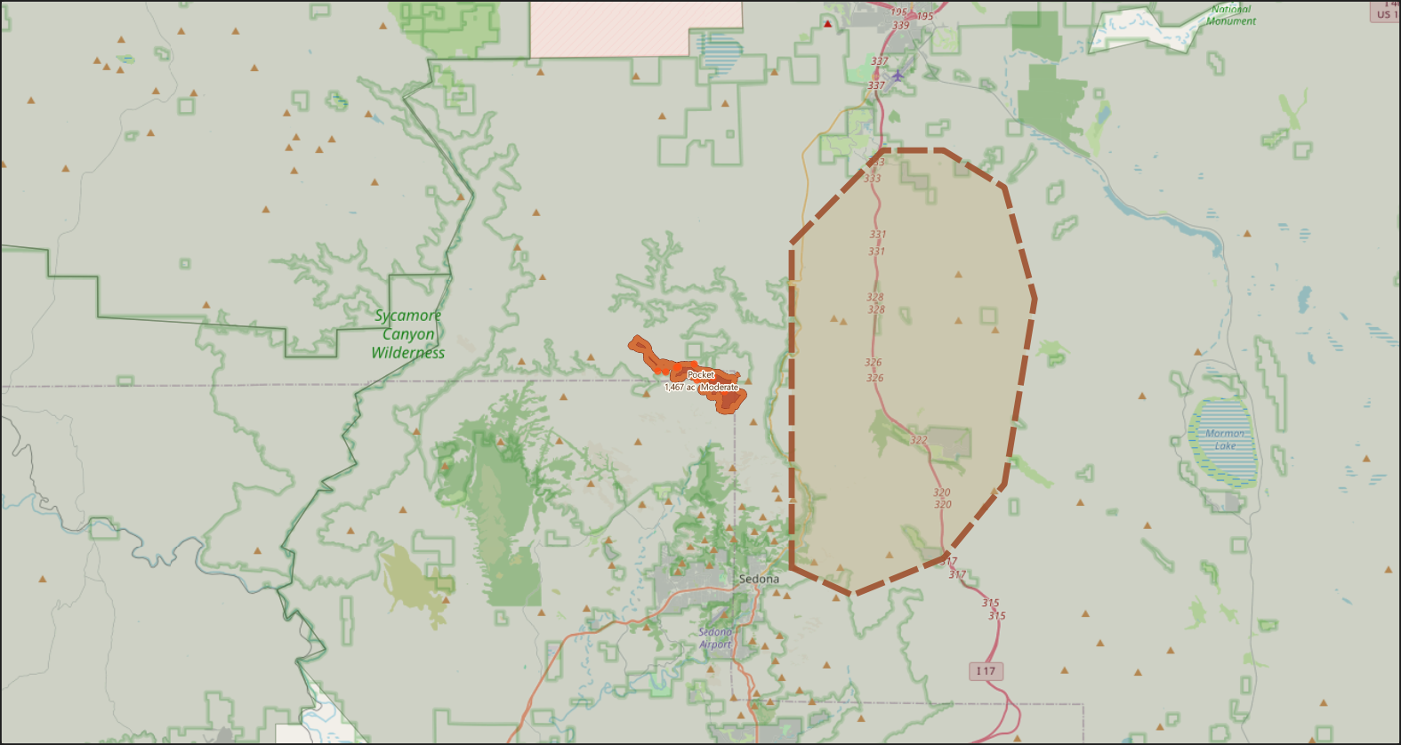
▲ Map rendered live from QGIS — Pocket Fire perimeter (orange) at 26,803 acres, remaining SET evacuation zones (dashed), MODIS 48-hr thermal hotspots (triangles), Coconino National Forest (green), Red Rock–Secret Mountain Wilderness (dark green). Sedona visible bottom-center. Source: NIFC WFIGS / MODIS / USFS / OpenStreetMap · July 8, 2026
Evacuations & Community Impact
The evacuation picture has improved substantially. On Wednesday, July 1, Coconino County downgraded Kachina Village, Forest Highlands, and Pine Del from SET to READY status, following four days without significant fire spread in their direction. Oak Creek Canyon remains in SET status. On the Yavapai County side, however, the picture worsened briefly: on Friday, July 4, the Yavapai County Sheriff's Office placed the zone containing Seven Canyons and Enchantment into SET status as fire activity flanked south of Secret Mountain. Those communities remain in SET status today, with structure-protection crews working the area.
Sedona itself was never under evacuation. Uptown, West Sedona, Tlaquepaque, the Chapel area, and the Village of Oak Creek are all open. The main tourist approaches — State Route 179 from I-17 and SR-89A from Cottonwood — are unaffected. The Pocket Fire cost Sedona a Fourth of July holiday weekend it can't get back — the closure of the SR-89A canyon corridor to non-residents effectively severed the Flagstaff-to-Sedona tourist flow at its most valuable point in the calendar — but the town itself has remained operational throughout.
On Thursday, July 2, the incident team held a public meeting at Red Rock Junior and Senior High School — the meeting that had originally been scheduled for June 27 and then postponed multiple times. Fleishman told the crowd the north edge of the fire looked good, but the southern side was still the problem. He also asked visitors coming for the Fourth to please skip the fireworks. "I've been on multiple firework fires before," he said. "This is not the time for fireworks."
One injury has been confirmed: on Tuesday, July 1, an injured wildland firefighter was airlifted by short-haul helicopter from the Seven Canyons golf range and transported to Flagstaff Medical Center. Photos of the medevac operation circulated in the Sedona Red Rock News. No structures have been reported destroyed.
Active Closures & Orders — July 8, 2026
- SR-89A through Oak Creek Canyon (Sedona ↔ Flagstaff) — closed to public; residents with proof of identity only, must enter canyon from the south
- Woody Mountain Road (Forest Road 231) — closed
- Slide Rock State Park — closed
- All Oak Creek Canyon campgrounds, day-use sites, trailheads (Cave Springs, Pine Flat, Bootlegger, Call of the Canyon/West Fork, Oak Creek Vista) — closed
- NW Sedona trailheads — Soldier Pass, Thunder Mountain, Fay Canyon, Bear Mountain, Loy Canyon, Secret Canyon, Jim Thompson — closed
- Lake Mary — closed (helicopter water source)
- Coconino NF pocket-fire closure order — remains in effect
- Coconino NF Stage 2 Fire Restrictions — in effect forest-wide
- Temporary Flight Restriction (TFR) — active over fire area · if you fly, they can't
Incident Data
| Field | Value |
|---|---|
| Fire Name | |
| Unique ID | 2026-AZCOF-000781 |
| Discovery Date | June 19, 2026 (~5:01 p.m. MST) |
| Location | 7 miles north of Sedona, AZ · Red Rock–Secret Mountain Wilderness |
| County | Yavapai / Coconino |
| Current Acres | 26,803 |
| Growth Since Day 7 | +25,336 acres (18.3×) |
| Contained | 51% |
| Personnel | 1,238 |
| Injuries | 1 firefighter (short-haul medevac · July 1) |
| Structures Destroyed | None reported |
| Cause | Undetermined |
| Primary Fuel | Timber and Brush |
| GACC | Southwest Coordination Center (SWCC) |
| Management Team | California IMT 6 (prev. SW Complex IMT 2) |
| Rank in Sedona-area history | Largest since Slide Fire (2014) |
Fire Timeline — Full
What Comes Next
Fire officials have been openly telling the public that this fire may not be fully out until the summer monsoon arrives. That is not a failure of firefighting — it is a candid statement about the country involved. The Red Rock–Secret Mountain Wilderness contains sections where crews physically cannot get eyes on the fire's edge without helicopter insertion, and where dozer support is prohibited by law. Some sections will simply burn until rain puts them out, contained on all sides where terrain allows and monitored where it doesn't. For visitors: Sedona is open. For residents of Oak Creek Canyon: stay SET. For everyone: this fire has one more chapter to write, and its ending depends on the sky.
Resources & Emergency Contacts
Data sources: NIFC WFIGS Active Wildfires · InciWeb (azcof-pocket-fire) · Arizona Emergency Information Network (ein.az.gov) · Coconino National Forest · Southwest Complex IMT 2 & California Interagency IMT 6 daily briefings · MODIS Thermal (48-hr) · U.S. Census TIGER 2023 · OpenStreetMap · Sedona Red Rock News · KNAU · AZFamily · QGIS 4.0 live session via MCP bridge. Map generated July 8, 2026. All acreage and containment figures reflect the July 7 morning briefing — the most recent operational summary available at time of publication.