If you’ve hiked through a boulder field in the Cascades in summer, you’ve probably heard one before you saw it: a short, squeaky eep from somewhere in the rocks. Then, if you stand still long enough, a small, round, grey-brown animal with round ears pops up on a boulder, looks at you, and disappears again.
That’s the American pika, Ochotona princeps. It looks like a hamster but it’s a lagomorph, a cousin of rabbits and hares. It lives in talus, the rockpiles that collect below cliffs, and it doesn’t hibernate. Instead it spends the summer cutting grasses and wildflowers and stacking them in “haypiles” under the rocks, so it has something to eat under the snow all winter.
It is also, for better or worse, the most famous small mammal in climate-change science. Pikas have been called the canary in the coal mine of the mountains. So when I built a tool that pulls citable downloads from GBIF, the Global Biodiversity Information Facility, the pika was the first animal I pointed it at, with one question: are pikas being found higher up than they used to be?
The answer turned out to be more interesting than yes or no.
Why everyone worries about the pika
Pikas run hot. Their body temperature sits above 40 °C, and they don’t handle heat well. In a field study published in 1974, Andrew Smith trapped pikas at dawn and held them in outdoor cages; two of them died at about 12:30, when the air had reached 29.4 °C for one and just 25.5 °C for the other. In a lab in Alberta, Robert MacArthur and Lawrence Wang lost two pikas after two hours at 28–30 °C. That’s a warm afternoon in a lot of places, not a heat wave.
In the wild, pikas cope by staying in the rocks, where the air is much cooler than the sunny surface, and by doing their haying in the cool parts of the day. But an animal that can be killed by a warm afternoon, that lives on islands of rock in a sea of warmer slopes, and that doesn’t travel far, is exactly the kind of animal you’d expect to be squeezed upslope as the climate warms.
An animal that can be killed by a warm afternoon, living on islands of rock in a sea of warmer slopes.
The case for alarm
The best evidence comes from going back to places where pikas were recorded long ago and looking again.
- The Great Basin. In the late 1990s, Erik Beever and colleagues revisited 25 isolated pika populations in the mountain ranges of the Great Basin that had been recorded earlier in the century. Seven of the 25 appeared to be gone. The ones that hung on tended to be higher, with more talus, farther from roads and free of livestock grazing.
- Faster, recently. A follow-up in 2011 found the rate of local extinctions there had increased nearly five-fold in the previous ten years. The lower edge of where pikas lived had moved upslope by about 13 m per decade over the 20th century, and by about 145 m per decade since 1999.
- Yosemite. Craig Moritz and colleagues re-ran Joseph Grinnell’s small-mammal surveys from the early 1900s across Yosemite National Park. Many species had shifted their ranges uphill. For pikas, the lower limit had risen by 153 m.
- California. Resurveys of 67 historical pika sites across California found them gone from 10. Warmer summers and smaller patches of talus best predicted which sites had been lost, and the models projected losses of 39% to 88% of those sites by 2070.
The case for calm
Then again…
- The Sierra Nevada is full of pikas. Constance Millar and Robert Westfall checked 420 talus sites with signs of pikas in the Sierra Nevada and western Great Basin and found pikas still living at 94% of them. Most of the occupied sites were on rock glaciers and similar ice-shaped rubble. Inside those rockpiles, they measured temperatures 4–7 °C cooler than the ground surface around them in summer, and warmer in winter. Their conclusion: pikas there “appear to be thriving.”
- The Southern Rockies too. Liesl Erb and colleagues revisited 69 historical sites in southern Wyoming, Colorado and northern New Mexico and found pikas still at 65. The four lost sites were drier on average, so water may matter as much as heat there.
- Pikas at sea level. In Oregon’s Columbia River Gorge, pikas live in mossy talus close to sea level. Johanna Varner and Denise Dearing found moss made up more than 60% of their diet at two sites. Moss is available all year, so these pikas don’t need such big haypiles.
- The big review. In 2020, Andrew Smith, who has been studying pikas since the 1970s, reviewed all of it and concluded that occupancy across the major mountain ranges is “uniformly high,” and that “the narrative that American pikas are going extinct appears to be an overreach.” The losses are real, he wrote, but they’re concentrated at low, hot, marginal sites, mostly in the Great Basin.
The regulators landed in the same place. The U.S. Fish and Wildlife Service found in 2010 that the pika did not warrant listing under the Endangered Species Act. California made it a candidate for state protection in 2011, then declined to list it in 2013.
So which is it? I wanted to see what the records themselves would say.
Pulling the records
GBIF gathers occurrence records from museums, surveys and community science apps into one place. I asked it for every georeferenced American pika record with no flagged location problems. That download has its own DOI so anyone can check it: 16,891 records, from a specimen collected in 1871 to iNaturalist photos posted this year.
Two kinds of record make up nearly all of it. About 6,700 are preserved specimens in museum drawers, most collected before 2000. About 10,000 are human observations, overwhelmingly iNaturalist photos from the last fifteen years. That split is going to matter.
For every record, I looked up the ground elevation at its coordinates from the Copernicus 30 m elevation model. Then I plotted elevation against latitude.
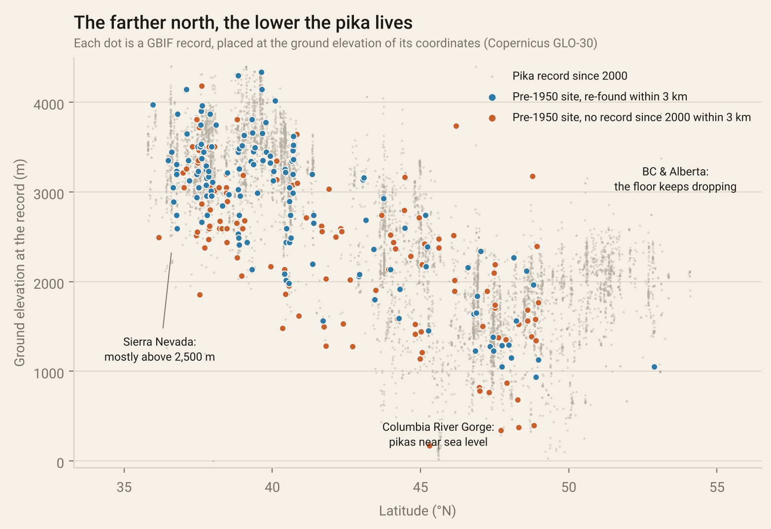
Every pika record in GBIF, at the ground elevation of its coordinates. Grey: records since 2000. Blue and rust: the pre-1950 museum sites, explained below.
That’s the pika’s whole world in one picture. In the Sierra Nevada, at 36–38°N, they live mostly above 2,500 m. Going north, the band slides lower, until in Washington and British Columbia pikas live from the high peaks down to a few hundred metres. And there’s that column at 45.6°N reaching down to near sea level: the Columbia River Gorge.
The chart also caught a mistake. A batch of pikas collected near Mount Rainier in 1919 was georeferenced to the summit, at 4,400 m. No pika lives up there. The labels written by the collector put them between 1,330 and 1,680 m. For the old specimens I used the label elevation where there was one. Where both exist, the label and the elevation model agree closely: a median difference of 3 m across 995 pre-1950 specimens, with half within 72 m.
The tempting number
Here’s the easy analysis. Split the records by era, before 1950 and since 2000, and compare the median elevation in each one-degree band of latitude.
The modern records are higher in 16 of 17 bands, by a median of 246 m. The lower edge (the 10th percentile) is up 351 m. Pikas fleeing uphill, case closed?
No. Look at who’s holding the camera. The old records are museum specimens, collected by biologists wherever their expeditions took them, often by road and pack train. The new records are iNaturalist photos taken by hikers, and hikers go to the high country, to the trailheads and passes and summits. Ecologists call this a change in sampling, and it’s the classic trap when comparing old and new occurrence data. Morgan Tingley and Steven Beissinger wrote the paper on it in 2009.
You can see the trap in the state numbers. Comparing pre-1950 records to modern ones, Oregon’s median pika dropped about 300 m, because the Columbia River Gorge is a short drive from Portland and a lot of people photograph its sea-level pikas. Alberta’s rose nearly 700 m, because the Icefields Parkway puts tourists right at the alpine talus. Neither number says much about the pikas.
The trap
Comparing all old records with all new records mostly measures where people go now versus where collectors went then. To learn anything about the animal, you have to compare like with like: the same places, then and now.
Going back to the old sites
So that’s what I did, in a rough way. I took every pre-1950 museum record with a location known to within 2 km and grouped them into localities about a kilometre across. That gave me 276 historical pika localities, from 1,133 specimens collected between 1871 and 1949. For each one I asked a simple question: has anyone recorded a pika within 3 km since 2000?
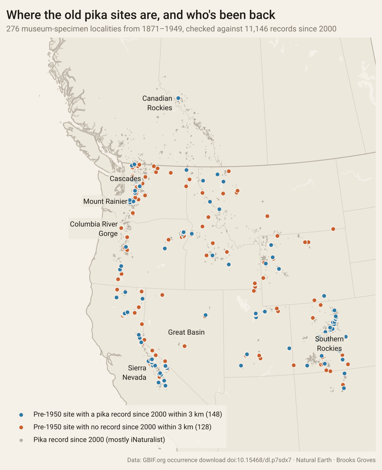
Blue: a pre-1950 pika site with a record within 3 km since 2000. Rust: no record since 2000 within 3 km. Grey: every record since 2000.
148 of the 276 have been. That’s a little over half. Where they have, the modern records sit at almost exactly the same elevation as the old ones: a median of 33 m higher, which is well within the noise of old georeferencing. At the old sites where pikas are still being found, they’re still being found where they were.
The interesting part is which sites haven’t been re-found. Because pikas live so much higher in the south than the north, I ranked each old site by how low it sits compared with all the pika records at the same latitude, and split them into thirds.
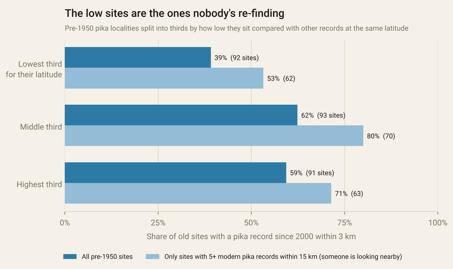
The share of old pika sites with a record since 2000 within 3 km, by how low each site sits for its latitude.
Only 39% of the lowest sites have a modern pika record nearby, against 62% and 59% for the middle and highest thirds.
That could still be the hikers: maybe nobody goes to the low sites. So I ran it again using only the old sites where people clearly are recording pikas nearby, with at least five modern records within 15 km. The gap stays: 53% of the low sites re-found, against 80% and 71% for the middle and the high ones.
Where pikas are still being found, they’re being found where they always were. The places they’re most often missing from are the low ones.
What this is, and isn’t
No record isn’t the same as no pikas. Most of these places haven’t been surveyed: a site counts as re-found only if someone happened to record a pika there and upload it. Some old coordinates are off by more than the 2 km I allowed. This is a screen of the records, not a resurvey, and the low sites are exactly where the resurveys above say to look.
So, what’s up with the pikas?
Both camps have a point, and the records show why they keep talking past each other. The field surveys say that across most of its range the pika is doing fine, and the records don’t contradict them: at the old sites where someone with a phone is still finding pikas, they’re at the same elevation as a century ago, with no sign of a wholesale march uphill. The trouble is at the bottom edge: the low, warm, isolated sites, the ones the Great Basin and California resurveys flagged, are the ones least often turning up in the modern record.
That fits what the field biologists found: an animal that isn’t vanishing, but is slowly losing its lowest, hottest outposts. And since pikas are poor travellers across warm ground, a lost low site probably stays lost.
Here in Washington, 15 of 36 old pika sites have a modern record within 3 km (part 2 goes looking for the other 21). Mount Rainier National Park has been watching its pikas since 2007 and has mapped about 900 pika sites, but says the trends haven’t been analyzed yet. North of the border, a 2015 study of 114 pika sites in Alberta concluded they’re likely to persist through this century, as long as they can keep moving upslope, which makes me happy, because those are the rockpiles along the Icefields Parkway.
How it was done: one GBIF download (DOI below) of every georeferenced Ochotona princeps record with no flagged geospatial issues, fetched by a GitHub Action with ground elevation added from the Copernicus GLO-30 elevation model. I kept records with a date between 32° and 58°N and west of 103°W, which drops 230: a few strays filed at museums’ home cities, records from Yukon and Alaska, a strip of the far BC coast, and 65 with no year. Historical localities are pre-1950 records with coordinate uncertainty of 2 km or less (the University of Kansas, University of Michigan and Field Museum give theirs in miles or with no unit, so their small values are read as miles first), grouped into ~1 km cells, using the label elevation where there is one. Modern records are from 2000 on, with uncertainty of 1 km or less or not stated. The code and numbers are on GitHub.
Your pika photos count. Every iNaturalist observation with a location ends up in GBIF (the Colorado Pika Project’s Pika Patrol app, with Johanna Varner from the podcast below as its scientific adviser, collects sightings for researchers too), and the next person to ask this question will be using them. The low sites need it most.
Go deeper
The pika debate is a good one to read both sides of. Start with the podcasts, where you’ll hear from two of the researchers above, then read Smith’s 2020 review; it covers everything.
What is it like to study the world’s cutest mammal? — Ever Wonder? from the California Science Center, 7 June 2023, about 20 min. Johanna Varner, of the moss-eating Gorge pikas, on why pikas make good climate sentinels and how she went from MIT engineering to pika ecology.
How pikas can survive extreme conditions — Ever Wonder?, 13 September 2023, about 13 min. Varner again, on haypiles, snow as insulation, and the pikas that bounced back within two years of a wildfire.
Rabbit Relatives Reel from Climate Change — Scientific American Science Quickly. A short one: Joseph Stewart, of the California resurvey above, on pikas disappearing from a 64-square-mile stretch of the northern Sierra Nevada.
American Pika — Wild About Utah, Utah Public Radio, 16 September 2024, 3½ min. Jack Greene on the “rock rabbit” haying above Alta.
Beever, E.A., Brussard, P.F. & Berger, J. (2003). Patterns of apparent extirpation among isolated populations of pikas (Ochotona princeps) in the Great Basin. Journal of Mammalogy 84, 37–54. — seven of 25 populations gone.
Beever, E.A., Ray, C., Wilkening, J.L., Brussard, P.F. & Mote, P.W. (2011). Contemporary climate change alters the pace and drivers of extinction. Global Change Biology 17, 2054–2070. — the speed-up after 1999.
Moritz, C., Patton, J.L., Conroy, C.J., Parra, J.L., White, G.C. & Beissinger, S.R. (2008). Impact of a century of climate change on small-mammal communities in Yosemite National Park, USA. Science 322, 261–264. — the Grinnell resurvey.
Stewart, J.A.E. et al. (2015). Revisiting the past to foretell the future: summer temperature and habitat area predict pika extirpations in California. Journal of Biogeography 42, 880–890.
Smith, A.T. (2020). Conservation status of American pikas (Ochotona princeps). Journal of Mammalogy 101, 1466–1488. — the review. Read this one.
Millar, C.I. & Westfall, R.D. (2010). Distribution and climatic relationships of the American pika (Ochotona princeps) in the Sierra Nevada and western Great Basin, U.S.A.; periglacial landforms as refugia in warming climates. Arctic, Antarctic, and Alpine Research 42, 76–88.
Erb, L.P., Ray, C. & Guralnick, R. (2011). On the generality of a climate-mediated shift in the distribution of the American pika (Ochotona princeps). Ecology 92, 1730–1735.
Varner, J. & Dearing, M.D. (2014). Dietary plasticity in pikas as a strategy for atypical resource landscapes. Journal of Mammalogy 95, 72–81. — the moss-eating pikas of the Gorge.
Shank, C.C. (2015). Are American pikas (Ochotona princeps) in the Canadian Rockies vulnerable to climate change? Canadian Field-Naturalist 129, 254–262.
Smith, A.T. (1974). The distribution and dispersal of pikas: influences of behavior and climate. Ecology 55, 1368–1376.
MacArthur, R.A. & Wang, L.C.H. (1973). Physiology of thermoregulation in the pika, Ochotona princeps. Canadian Journal of Zoology 51, 11–16.
Tingley, M.W. & Beissinger, S.R. (2009). Detecting range shifts from historical species occurrences: new perspectives on old data. Trends in Ecology & Evolution 24, 625–633. — why old-versus-new comparisons are hard.
GBIF.org (5 October 2026). GBIF Occurrence Download https://doi.org/10.15468/dl.p7sdx7 — the 16,891 records behind every chart here.
U.S. Fish and Wildlife Service 12-month finding on the American pika — Federal Register 75, 6438, 9 February 2010.
American Pika at Mount Rainier — National Park Service.
If you’re in the mountains this fall, listen for the eep. They’re busy right now, finishing the haypiles.