Drive the Tamiami Trail across Big Cypress National Preserve and you’ll see them out in the wet prairie: round islands of trees, low at the edges and rising to a crown in the middle, like a green hat set down on the grass. They’re cypress domes, and their shape has a story in it.
Cypress trees grow tallest where the water stands deepest and longest. In a dome, the ground dips a little in the middle, so the centre stays flooded deepest and longest and the trees there grow tallest; toward the dry rim they get shorter and shorter. Seen from above, the height of the forest is a kind of map of the water underneath it. CYPRESS-DOME-WATCH is my attempt to read that map.
Finding domes with a laser
The trick is lidar, the same airborne laser behind Project Kiva. Some of its pulses hit the treetops and some reach the ground, and the difference between the two is the height of the forest. A 2018 USGS survey of the western Everglades covers the country around the Kirby Storter Boardwalk, where a boardwalk runs from sawgrass prairie into the cypress swamp.
The first version downloaded whole lidar tiles, about 220 MB each, which kept it to a few square kilometres around the boardwalk and found 12 domes. This week I switched it to the same trick that made the Kiva atlas easy: the whole USGS archive sits on Amazon’s cloud in a format you can read a window at a time. So now it streams a 6 × 6 km block, a square kilometre at a time, 36 of them side by side on GitHub’s computers, without downloading a single tile.
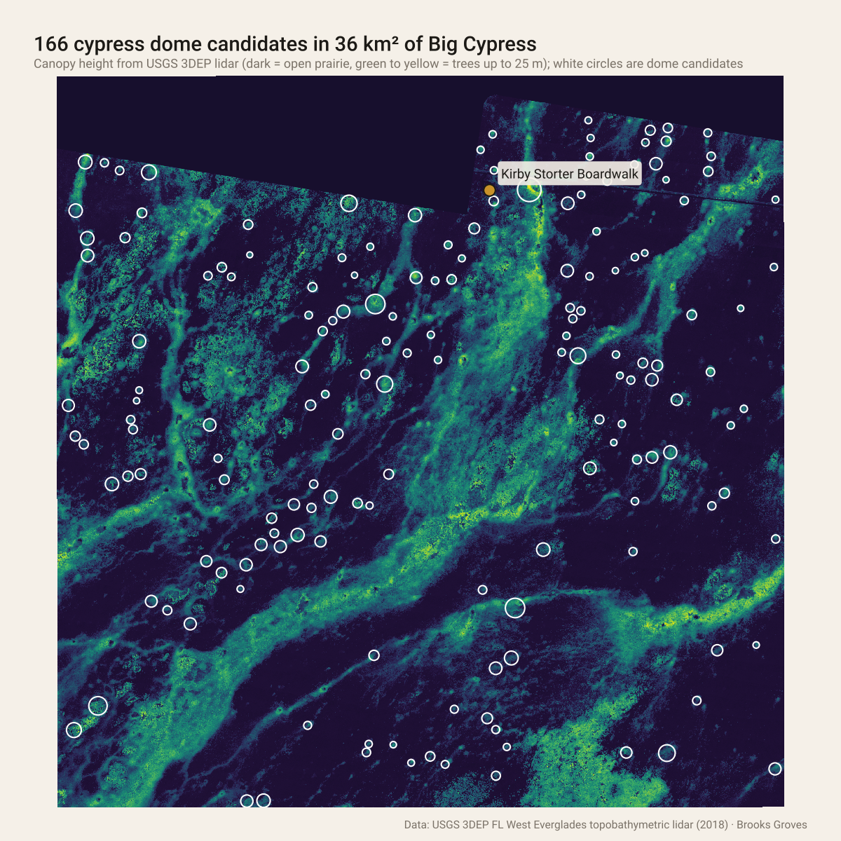
Canopy height around the Kirby Storter Boardwalk. The long bands are cypress strands; the white circles are the round, isolated islands the detector calls domes.
The detector looks for round patches of forest that rise toward the middle and stand alone in open prairie. That last part matters: the long rivers of trees you can see in the map, cypress strands, can look like a string of domes once they’re chopped up, so a candidate only counts if the ring of ground around it is mostly open.
166 domes, and the average one
In those 36 square kilometres it found 166 dome candidates, from about 50 m across to almost 200 m; the typical one is about 70 m across. The biggest sits just a few hundred metres from the boardwalk.
Then I asked each one the question the whole project is built on: does the forest really rise toward the middle? For every candidate I measured the canopy in rings from the centre out past the edge. 150 of the 166 stand more than 2 m taller in the middle than at the rim, and the typical dome rises about 6 m. Stack them all up, scaled to the same size, and you get the average dome:
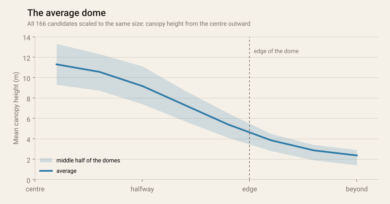
Every candidate scaled to the same size. The canopy falls from about 11 m in the middle to about 5 m at the edge.
A fair warning
A tall middle is partly built in, because the detector starts from high points. What isn’t built in is the smooth, steady slope down to the rim, and that’s the dome shape. These are still candidates, too: the next step is checking them against aerial photos and, better yet, against the water itself.
What’s next: does the shape match the water?
The idea I want to test is that a dome’s shape tells you how long it holds water. Ordinary satellite photos can’t see water under a forest canopy, but radar can: when a dome floods, Sentinel-1’s radar bounces off the water and back up the trunks and the dome lights up. With ten years of passes at least every 12 days, I should be able to tell which domes stay wet longest, and see whether the steepest, tallest-centred domes are the wettest ones.
How it works: USGS 3DEP lidar (FL West Everglades topobathymetric survey, 2018) streamed from the Entwine Point Tile archive on AWS with PDAL, one square kilometre per GitHub Actions job. Ground and underwater-bottom returns become the bare earth; every other return gets its height above it, and the tallest in each 1 m cell makes the canopy model. Domes are found by smoothing to dome scale, growing regions from the high points and keeping the round, isolated ones. The code is on GitHub.
Every dome, with its own height profile, is on the map: click one to see how it rises.
Open the dome map Code on GitHubGo deeper
USGS 3D Elevation Program lidar, read from the USGS 3DEP archive on AWS.
Big Cypress National Preserve (National Park Service), home of the Kirby Storter Roadside Park and its boardwalk on the Tamiami Trail.
Related: Project Kiva, the same lidar trick pointed at archaeology, and ALPINE-WATCH, mountain lakes from space.
If you’re ever on the Tamiami Trail, stop at the boardwalk and walk out into one. It’s cooler and quieter under the trees than you’d think.